Matt's Weather Rapport is written by Vermont-based journalist and weather reporter Matt Sutkoski. This blog has a nationwide and worldwide focus, with particular interest in Vermont and the Northeast. Look to Matt's Weather Rapport for expert analysis of weather events, news, the latest on climate change science, fun stuff, and wild photos and videos of big weather events. Also check for my frequent quick weather updates on Twitter, @mattalltradesb
On top of everything else, a massive dust storm ripped through parts of southeastern Australia this week.
I"m going to need to re-name this blog, "Australia Weather Rapport" since all the extremes and action, not to mention the politics of weather are happening Down Under.
Sure, those super destructive, super scary bush fires are still a threat. Summer isn't over in Australia yet.
But this week, new extreme weather decided to enter the mix. These included massive dust storms, massive hail storms and some serious flash floods.
No doubt some of the storms were extremely welcome. After all, they doused some of those fires. A win! Yet with all the damage Australia has suffered in the past couple of months, the hail, the wind, the floods, the dust, just added that much more devastation.
Who knows what will happen next in Australia? As the several dramatic videos below show, I'm sure Australians just want their awful summer of 2020 to end.
Here's an overview from The Guardian:
The Australlian Capital of Canberra was especially hard hit with hail as supercell thunderstorms rolled through. Sydney got nailed, too. Here's a News 9 report:
Not a nice day at this Canberra outdoor restaurant:
Aftermath of hail in Canberra makes it look like they were hit by a New England style winter storm:
Meanwhile, elsewhere in Australia, check out this kabob/dust storm in part of New South Wales this week: This wall of dust was reportedly was 180 miles long as it rolled over the region. When the dust storm hit the town of Dubbo, winds reached around 66 mph.
An avalanche begins to engulf Interstate 70 in Colorado
a few days ago. Nobody was hurt.
UPDATE 3 PM 3/7/19
The avalanche situation in Colorado has definitely worsened since Tuesday.
The National Weather Service in Denver/Boulder has anavalanche warningfor most parts of the Colorado Rockies into Friday morning at least.
There's an extreme danger of avalanches in some of Colorado's mountainous regions. The NWS avalanche warning doesn't kid around: "We may see avalanches of historic size. These avalanches will be very destructive and may run to the valley bottoms."
That warning is important, because usually, Rocky Mountain avalanches usually largely stop before reaching valley floors, where most people are. So this goes beyond the usual danger avalanches pose to backcountry skiers and hikers most winters.
The danger is particularly acute today after a series of intense storms dumped up to two feet of dense snow atop lighter, more powdery snow. This makes the snow pack very unstable. Strong winds are blowing across Colorado's mountains today, making things all that much worse.
The Denver Post reports that this is the worst winter in decades for avalanche danger in Colorado.
"'We are seeing avalanches run longer than thehy have in 50 years in some cases,' said Spencer Logan, an avalanche forecaster for the Colorado Avalanche Information Center. 'We've gotten a lot of snow on the mountains and it is starting to come down,'" says the Denver Post.
Another Colorado avalanche this week. Image via
Twitter from Denver 9News
The Avalanche Center, known as CAIC,says there have been about 2,000 avalanches in Colorado this winter. In an average year, there are about 3,000 avalanches, but most of those occur in the spring when the snow is starting to melt.
That means when the current avalanche warning expires Friday, the risk is far from over. I'm sure there will be plenty more such warnings in Colorado during the coming weeks. Already six people have died in Colorado slides this winter.
Interstate 70 through the Colorado mountains is closed again today. In my earlier post, as you will see below under "Previous Discussion," the highway closed Sunday when avalanches struck vehicles on the road. Interstate 70 closed again Tuesday while officials intentionally set of avalanches to help prevent larger more destructive ones from launching on their own.
But today, two giant avalanches near Vail and Copper Mountain closed Interstate 70 again today. The avalanche near Copper Mountain ruptured a gas line. The one near Vail hit a truck, but the driver was not injured and a tow truck pulled the vehicle out.
Parts of State Highways 91 and 24 were also closed because of avalanches or worries about them.
Some ski areas, like Breckenridge, closed upper mountains to skiers so that they will stay safe.
At least one pickup truck was pushed off the road, and several motorists had to crawl out of sunroofs or car windows to escape once the avalanches subsided. Many of these motorists then had to spend hours digging out their cars to continue on their way.
Although avalanches in the mountains are fairly common, ones that impact highways are not. Colorado highway officials said these were the first avalanches to hit a major Colorado highway since 1983.
The Colorado Rockies have been hit by unusually heavy snowstorms in recent weeks, leading to the increased avalanches.
Colorado isn't the only state dealing with avalanches crashing down onto highways. In Idaho, a snow slide buried a one quarter mile long part of Route 21 between Lowman and Stanley beneath up to 40 feet of snow. Nobody was hurt there, either.
A couple of dramatic videos from dash cams emerged from the Colorado avalanches. Scary!
Here's the first one:
Here's another, more expansive view from a motorist who avoided getting directly hit:
One of the damaging tornadoes in Virginia Monday, part of the remains of Florence
The remains of Hurricane Florence still had quite a punch Monday, unleashing tornadoes on Virginia that killed at least one person.
Dramatic video at the bottom of this post shows it ripping roofs off buildings and flinging the debris high into the air.
A flooring company warehouse collapsed on workers during the tornado in Chesterfield County, Virginia, killing one employee and injuring another. This brought the overall death toll from Florence so far to 32.
The very last gasp, or what we think is the last gasp, is in southern New England this morning, promptingflash flood warningsin southern New Hampshire and northern Massachusetts flood advisories in far southern Vermont, and flood warnings in parts of New York.
The rain avoided parched northern Vermont, and only scattered light showers might fall today as a couple of cold fronts come through. Nothing heavy. but the unseasonably hot, humid weather is ending and we will get into a spell of cool autumn weather, with the exception of a brief warmup Friday.
It has stopped raining in North Carolina, but the flooding on some rivers is only just peaking, and it will take many days for all of them to recede so cleanup can start.
FIRE WHIRL SUCKS UP HOSE
A viral video making the rounds shows a "a fire tornado" during an August 19 wild fire in British Columbia sucking a fire hose up into the air. This video is also at the bottom of this post.
Firefighter M,C. Schidowsky wrote on Instagram:"Fire tornado destroyed our line. It threw burning logs across our guard for 45 minutes and pulled our hose 100 plus feet in the air before melting it. That's definitely a first."
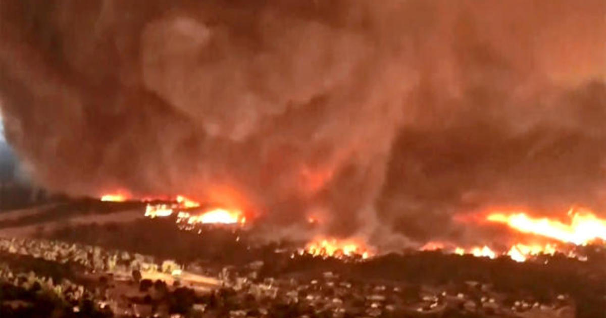
Seems like fire tornadoes are now a thing, give the history with that one in California earlier this year that destroyed homes around Redding, California.
First, here's the tornado video from Virginia, after that will be the fire tornado/hose video.
Mud flies into the air in a Swiss village as a debris flow caused by
heavy rain in the mountains crashes through town
Weather can be photogenic, that's for sure. And those images tend to end up on YouTube.
Below is a collection of some of the best ones I've seen lately. At least ones that don't have anyting to do with Typoon Jebi, Tropical Storm Gordon or the Midwest floods.
These videos are all fascinating, but I think the last one in this collection is the most dramatic.
So here goes:
Mid and late summer are monsoon season in the Desert Southwest, and some of the storms really are doozies. Some videos illustrate this point.
On Lake Powell, the summer monsoon season brought on this incredible microburst. As one person on the video says, "It's like an avalanche."
In mid-August, this microburst was strong enough to remove lots of shingles from this house in Arizona:
I'm not sure where this microburst happened, but boy, when you time lapse these things, it shows their power. Looks like a violent waterfall
Here's a frightening video taken in Glacier National Park during recent wildfires there. A father and son who had been hiking got caught in the wildfire. They tried to drive out as the temperature in their car got hotter and hotter. Then they encountered a flaming, fallen tree across the road. They backed up all the way to where they started.
Spoiler: Somehow, they survived. Firefighters picked them up at the shore of a lake:
In early August, a debris flow hit Chamonson, Switzerland. Severe storms in the mountains set off the mudflow that crashed through the picturesque village. It's really scary, but luckily no injuries were reported.
Terrifying helicopter view of massive fire tornado" ripping
through Redding, California neighborhoods.
I know I've gone gaga over that terrible "fire tornado" during the Carr Fire around Redding, California earlier this summer. I've already done a couple posts about it.
New footage, from a helicopter and a fire truck has emerged showing the incredible power and huge size of this tornado like whirl.
As I've previously reported, a National Weather Service analysis of this thing indicated it had winds as high as 143 mph - very much like a strong EF-3 tornado.
An additional video shows the fire tornado crossing the Sacramento River while staying intact and powerful. Quite the scene!
Here's the new videos:
This video shows the fire tornado going out onto the Sacramento River. A hellish scene of fire on water:
A non-severe storm over Milton, Vermont last evening
I'm not aware of any of Tuesday's thunderstorms becoming severe in Vermont yesterday, so that was kind of a fortunate bust.
There were locally heavy downpours and some wind gusts, but nothing extreme.
That's not to say there wasn't action elsewhere, though. I've got a couple of videos to show you:
This week, Stormlapse recorded a gorgeous, menacing supercell thunderstorm over the Badlands of South Dakota.
Quite an impressive storm, watch:
I'm not sure when the next video was taken, but it's an illustration of what happens when a thunderstorm rolls into Atlanta's Hartsfield airport, the world's busiest.
You see the planes trying to fly around the storms, go in circles, and just kinda hope this thing passes quick. I'm sure there were quite a few flight delays on this day:
A few times each spring and early summer, storm chasers converge on almost "perfect" supercell thunderstorms and tornadoes.
An immense tornado near Dimmitt, Texas Friday evening The supercell storm created at least six tornadoes. This image via Twitter @Stasischasing
Each of thes supercells produce multiple tornadoes, plus giant hail, violent winds, flood-producing rains, vivid lightning and spectacular cloud features.
It obviously helps immensely when the tornadoes in question avoid towns and cities and stay out over open country.
Such was the case Friday evening, when a giant supercell fired up near the town of Dimmitt, population about 4,800 in the Texas panhandle southwest of Amarillo.
This supercell was almost stationary for several hours, meaning the tornadoes were slow moving, or even sat over the same spot for a long time - about three hours - which is also obviously dangerous.
This also must have kept the residents of Dimmitt alarmed for a a long time, because unlike most tornadoes and severe storms, this one wasn't moving on. Would a tornado break free and plow through the town?
One of Friday night's Dimmitt, Texas tornadoes via stormchasing.com.au
Dimmitt itself wasn't too badly damaged, even though the storm produced at least six significant tornadoes
The slow or non-existent movement of the supercell also meant incredible amounts of rain and hail fell, leading to serious flash flooding. Up to 12 inches of rain was reported in some areas around Dimmitt.
You'll see in the videos below how the tornadoes blossom, beome big, then "rope out" meaning they get skinnier and skinnier until they dissipate. Then a new one forms.
It was even fascinating for me to watch the tornadoes unfold on radar, viewing it on my laptop fromo the safety of Vermont, where the sky was clear and the wind was calm.
You'd sometimes see three simultaneous tornado circulations on radar image, which is pretty impressive for a single storm.
As is the case most of the time in April, there's a threat of severe weather and possible tornadoes almost daily for the foreseeable futurein various spots in the middle and southern parts of the United States.
This has so far been quite a year for severe weather. The Weather Channel saysthere have so far been more than 5,000 reports of tornadoes, thunderstorm wind damage and large hail in 2017, double the average.
There have even been unprecedented early tornadoes in February as far north as Massachusetts and Minnesota.
So far in 2017, only seven states, including Vermont, that have not reported any damage from severe thunderstorms.
We'll see if the trends continue.
Here's some video of the Dimmitt storms.
Through much of this video, one of the tornadoes near Dimmitt appears to want to "rope out" but maintains its strength, looking like a drill bit as it crosses the Texas prairie:
In this video, it looks like the storm chaser was a little too close to one of the Dimmitt tornadoes when it was a powerful wedged-shaped monster:
The view of stormchasers just before driving into
an oncoming tornado on this Louisiana highway
The tornado was luckily weak
Despite the deaths in recent years and the danger, some storm chasers are getting way too cocky in their bids to get the most dramatic tornado videos, for fun, viewer clicks and profits.
This has created a backlash, and one of the more blistering ones hit Bart Comstock, who drove his care into what was fortunately a relatively weak tornado near Lena, Lousiana a few days ago.
A little over a week , National Weather Service meteorologists issued alerts for the potential of particularly dangerous tornadoes in northern Louisiana. The forecasters worried some of the tornadoes that would form would be exceptionally strong and long lasting and deadly.
Needless to say, hordes of storm chasers converged on northern Louisiana.
One of them was Comstock and his crew. They spotted what they judged (correctly, it turned out) to be a pretty weak, but still impressive tornado.
"After spotting the tornado, video from Comstock and his crew shows the chase vehicle take off at a high speed straight for the twister - as its engine roars. A second camera view from the same vehicle....shows the driver with one hand on the steering wheel, the other with a camera photographing the storm. 'We're in it, we're inside the tornado right now,' one of the crew says while another chaser is heard laughing in the background. The car is nearly blown off the road, while the chasers shout excitedly, "Whoa!" After the encounter, one of the crew boasts, tweeting, "OMG, Just took a DIRECT HIT from a #tornado in Lena, LA. Got great footage, mult cameras.'"
Yeah, that sounds pretty reckless.
As a side note, you shouldn't be holding a camera with one hand a steering wheel with another even while driving in nice weather, never mind a tornado.
These chasers and meteorologists took to Twitter right away to blast Comstock.
"You're doing it wrong...Takes direct hit and brags about having video," tweeted Victor Gensini a meteorology professor at the College of DuPage who leads student storm chasing tours.
"This is not a badge of honor, nor is it a good example. Bragging about it is tone deaf," said National Weather Service meteorologist who storm chases in her spare time.
"I try not to be judgmental.....but storm chasers driing INTO a tornado essentially laughing all the way. That's...not a good look," tweeted Houston meteorologist Matt Lanza.
Comstock argues that he is an experienced storm chaser and only takes calculated risks.
He had a direct message chat about it with Marshall Shepherd, a meteorologist, who among many other things, writes for Forbes magazine.
Comstock said radar indicated that if there was a tornado near Interstate 49 in Lena, it wasn't strong and didn't show signs of getting stronger. They stayed south of the storm cell, which would have meant they had an escape route if things escalated.
The storm chasers figured the tornado would weaken, as its parent storm's energy was being damaged by another nearby storm. Thus, they decided to drive into it. Had it been a stronger storm, Comstock said, they would have stayed away.
"Our choice to get closer and then transect the tornado was not made as lightly as the video may make it appear," Comstock said.
What about less experienced storm chasers who see that video, see what they think is a weak tornado and drive into it? And then the tornado strengthens, or is worse than what appears from a distance? Doesn't that risk peoples' lives?
"Simply because I do something when chasing does not mean I condone nor do I want others to copy me. Especially those who may only have limited experience with storms and chasing. Driving into tornadoes is dangerous no matter how strong they are. I took a calculated risk but not one with 100% odds that I would come out unscathed."
Of course, people like me are perhaps culpable, too. After all, I do share these videos from time to time. And I'm putting Comstock's in this post, so you can see exactly what we're talking about. But by doing so, am I encouraging risky behavior?
I'm not sure.
On the one hand,as Shepherd notes, you want to bring the awe and excitement of science into the mainstream. On the other hand, you don't want to put people in harm's way.
No matter what, it's always going to be a matter of walking a fine line in these matters.
Severe weather and tornado season is ramping up toward its peak in late April, May and June. There's going to be a lot of new tornado videos coming out in the next few months. How many risks will people take to get the "money shots" of these tornadoes? And will they be worth it?
I'll repeat. I'm not sure.
For what it's worth, here's the video of Comstock and his carload of chasers excitedly driving into the Lena, Louisiana tornado. As you can see, the tornado wasn't too dramatic, as tornadoes go, but what if it surprised them?
But as the video shows, tons of people go down there anyway. Even after, as you see in part of the newsclip that is the video, a woman got hurt when a big chunk of ice recently gave way.
Despite the obvious danger, people are still going right up to the falls. Even more dangerously, they're going behind the big ice cliffs that have formed there, which is really scary.
Watch:
Next, as I mentioned yesterday, central and eastern Europe is having a rough time with big snowstorms ane intense cold lately.
Suddenly, as you see in the video below, the players and spectators heard and saw something, so they bolted for the exits.
Then the roof comes down under the weight of 15 inches of snow. Luckily, the collapse happened slowly enough so that everybody got out of the building safely.
The collapse sent a mini-tsunami crashing onto the beach. Everybody got out of the way and nobody was hurt. The collapse was captured on the really cool video you'll see below.
Icebergs make pretty frequent visits to Newfoundland and surrounding areas of eastern Canada.
Here's the video, followed by more videos of icebergs this summer around Newfoundland and Labrador. Apparently, these iceberg dramas are fairly common up there.
Here's an iceberg collapsing near Twillingale, Newfoundland on July 3:
And here's a drone view of an iceberg collapsing in Labrador back in June: